|


Stay up to date on the latest sites featuring
Irish historical and cultural themes!
Request
your
free newsletter!


|
  Being
a traditional name of great age, there are numerous accounts for the linguistic
origin of �ire. In the early Irish manuscripts the variant of �riu was
commonly used. The contemporary name is a later Anglo hybrid, setting
the island as the 'land of �ire.' It serves as an appropriate reference,
for in ancient mythology, �ire is one of a trinity of goddesses who represent
the personification of the island itself. Being
a traditional name of great age, there are numerous accounts for the linguistic
origin of �ire. In the early Irish manuscripts the variant of �riu was
commonly used. The contemporary name is a later Anglo hybrid, setting
the island as the 'land of �ire.' It serves as an appropriate reference,
for in ancient mythology, �ire is one of a trinity of goddesses who represent
the personification of the island itself.
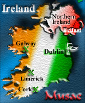 |
Ireland
is the westernmost country of within the European Union. The island
nation is separated from Great Britain by the North Channel on the
northeast and the Irish Sea on the east. Total coastline measures
1,448 km. |
The Republic of Ireland consists of Connaught, Leinster, and Munster provinces,
totaling 23 counties, and in the north, 3 counties of Ulster Province. Northern
Ireland consists of 26 districts, the remainder of Ulster Province.
National capital: Dublin
Primary cities by population: Dublin; Cork;
Limerick; Galway; Waterford.
Ports and harbors: Arklow, Cork, Drogheda, Dublin,
Foynes, Galway, Limerick, New Ross, Waterford
Climate: temperate maritime; modified by North
Atlantic Current; mild winters, cool summers; consistently humid; overcast about
half the time.
Terrain: mostly level to rolling interior plain
surrounded by rugged hills and low mountains; sea cliffs on west coast
Population: 3,619,480
Age structure: 0-14 years:
22%
15-64 years: 67% - 65 years and
over: 11%
Population growth rate: 0.36%
(Estimates are current to July 1998.)
Ethnic groups: Celtic, English
Religions: Roman Catholic 93%, Anglican 3%,
none 1%, unknown 2%, other 1% (1981)
Languages: Irish (Gaelic), spoken mainly in
areas located along the western seaboard, English is the language generally used
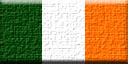 |
The
Irish flag consists of three color fields of equal share in a vertical
pattern. |
The design dates to the mid nineteenth century, it became
widely accepted after its use in the Easter Rising of 1916. The green field represents
the majority Catholic population. The orange field represents the Protestant population,
bearing the colors of William of Orange. The white field represents the promise
of a sustaining peace between the two.
Independence: 6 December 1921
Constitution: 29 December 1937; adopted 1 July
1937 by plebiscite. A full
text of the Irish constitution, Bunreacht Na h�ireann, is provided on-line
by the Irish government.
A primary source of information for this page is the Central Statistics Office (CSO)
for Ireland. In depth resources are available on-line regarding all essential indicators.
Stay up to date on the latest sites featuring Irish historical and cultural themes!
Request
your free newsletter!
|
|
Regional Index:
Together, Northern Ireland and the Republic
are comprised of four provinces, which consist of thirty two counties.


 Galway
Leitrim
Mayo
Roscommon
Sligo

Carlow
Dublin
Kildare
Kilkenny
Laois
Longford
Louth
Meath
Offaly
Wicklow
Wexford
Westmeath

Clare
Cork
Kerry
Limerick
Tipperary
Waterford

Antrim
Armagh
Cavan
Down
Derry
Donegal
Fermanagh
Monaghan
Tyrone
The counties of Cavan, Donegal and
Monaghan although part of the Republic of Ireland since 1922,
have traditionally belonged to Ulster Province.
The
country is also commonly divided up informally as North, East, South, West, Northwest
and the Midlands.
|